© Copyright Middlewich Heritage Trust 2025. Registered Charity No 1161871. Company Limited by Guarantee No 9441581
Made with 🤍 by Bloom Digital Marketing Ltd.
The site at Buckley’s Field lies within the general industrial area of Roman Middlewich, which developed along the fringes of King Street following the establishment of a military fort at Harbutt’s Field in around 70 AD. The site of the fort was identified in 1993 by geophysical survey (Figure 3), ruling out an earlier postulated site at Church Fields/Maidenhills (Waddelove 1990, 330-331). The Roman settlement exploited local brine springs for the production of salt, but also carried out metalworking, glass making and produced leather for which brine was also necessary.
Harbutts Fort Geophysical Survey
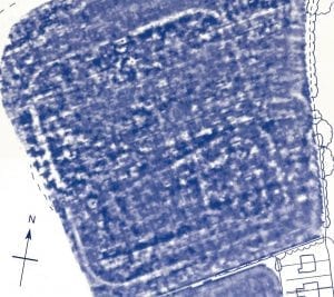
Figure 3: Geophysics plot of the Roman fort at Harbutts Field
Despite the fact that a significant amount of archaeological investigation has been carried out at sites along King Street since the 1960s, the archaeological potential of the current site remained largely unknown. John Bestwick excavated a number of small trenches in the northern corner of the field between 1972 and 1975 (referred to as Site J), but the results were never published. In the few interim reports that were produced he stated that evidence for 2nd-3rd century iron-smithing had been identified, and that an aisled, post-built structure associated with a 3rd-4th century potter was discovered. The exact location of these features is unknown as Bestwick left no plans, but it is probable that such features were present in the area behind the gardens of houses fronting onto King Street. In the Roman period these ‘backplots’ would have formed a focus for industrial activity.
Immediately to the northwest of the current site is a modern housing development constructed by Fairclough Homes. Prior to its construction in 2002-3, an archaeological excavation located a number of industrial features, including clay and wicker lined pits, ditches, kilns and fire pits, crossed by a substantial cobbled road constructed in several phases. This appeared to run in a westerly direction from King Street down towards the River Croco. This site had previously been excavated in 1960 by Harding and Blake, which also uncovered traces of timber buildings and a large brine kiln (Bestwick 1975, 66)
Around the edges of the site, briquetage and lead salt pans give evidence for (undated) salt-working, and a military diploma was found close to King Street, just to the north of the site. In this location a hoard of coins and evidence for buildings has also been recovered.
Following the end of the Roman period evidence for settlement to the east of the River Croco becomes sparse, and it is likely that the focus of the town shifted westward to Newtonia (or ‘New Town’). Historic maps of Middlewich in the 19th century show that Buckley’s Field had remained undeveloped in the post-medieval period. The 1875 Ordnance Survey map (Figure 4) indicates that Buckley’s Field formed part of a larger field, with a mill pond to the southeast and salt and gas works fringing the river to the west. It was not until the early 20th century that the housing to the east of the site was constructed along King Street.
First Edition Ordnance Survey Map

Figure 4: The site location in the 19th century
Further information on the archaeology and history of Middlewich and Cheshire can be found at the following online sources:
Middlewich Historic Town Survey- downloads a pdf report
Revealing Cheshire’s Past (requires registration)- online record of historic sites in and around Middlewich
e-mapping Victorian Cheshire- excellent tool to view historic tithe and Ordnance Survey maps of Middlewich